
Tracking the Impact – Results so far
Tracking the Impact is a landscape-scale wildlife surveying programme across the Central Chilterns and the River Chess catchment
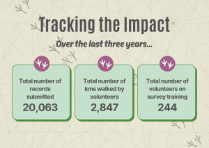
We have seen some incredible results so far – in the first four years of the project, our team of volunteers has helped reach 73% coverage of our project area, and has amassed more than 20,000 records! Of the possible 78 1km survey squares available from 2020-2023, 72 have been covered for the Breeding Bird Survey, 47 for the Wider Countryside Butterfly Survey and 43 for the National Plant Monitoring Scheme.
All of the records for the survey squares have been entered onto our online interactive maps, so you can see for yourself what birds, butterfly and plants have been recorded and where.
Explore our survey results on our interactive maps

Tracking the Impact – results from our plant surveys
Use our interactive map to see what plants have been recorded as part of our Tracking the Impact surveys
Tracking the Impact – results from our butterfly surveys
Use our interactive map to see what butterflies have been recorded as part of our Tracking the Impact surveys.

Tracking the Impact – results from our bird surveys
Use our interactive map to see what birds have been recorded as part of our Tracking the Impact surveys
Identifying long-term trends
One of the long term objectives of the project is to build a dataset that helps us to look at and review the impact of the great work farmers and other landowners are doing to support wildlife. We are doing this by tracking the distribution and abundance of our bird, butterfly and plant populations year-on-year. By doing so, we hope to be able get a better idea of what’s happening across the landscape.
We can review the impact of our work by using Tracking the Impact records for key bird, butterfly and plant species that we feel are typical indicators of our grassland, woodland, river and farmed habitats.
It will take a number of years of surveying to get a reliable dataset that can really show trends. But, in the short term, we have pulled together maps of the key species, where they have been recorded, and how many have been recorded to help build a baseline. Data will be added to this analysis each year and, in time, we hope to spot patterns and identify trends.
The maps for the first four years (2020-23) of data for the key species are available to download below – watch this space in the next few years as our datasets grow!
Read more on our blog

Tracking the Impact – the results are in!
Our award-winning wildlife monitoring programme, Tracking the Impact, has published the results of its surveys from 2023. It was an incredible year in which 8,104 records were collected!

Tracking the Impact – 2023 season ends on a high!
The 2023 Tracking the Impact season is over. Support continues to grow, and we would like to draw 2023 to a close by saying a huge thank you to everyone involved.

Tracking the Impact: In Celebration of Volunteers
Tracking the Impact - an online celebration of the role of the volunteers involved in this Citizen Science and conservation project.


Sign up to our newsletter
Check out our Youtube channel
