

Studley Green Red Kite Walk: full route
This circular stile free walk passes through beautiful Chiltern valleys where red kites are abundant. You can also enjoy panoramic views, ancient beech woods and rolling farmland. The walk is close to the place where red kites were first re-introduced and you will be very unlucky if you don’t see at least several of these wonderful birds.
By Paul Weller and Andrew Clark, Chiltern Society
Details of route
-
![Starting point icon]() Starting point Capital Gardens, Studley Green Garden Centre, Studley Green HP14 3UX
Starting point Capital Gardens, Studley Green Garden Centre, Studley Green HP14 3UX -
![Duration icon]() Duration
Duration -
![Distance Icon]() Distance 4.5 miles
Distance 4.5 miles -
![OS Ref Icon]() OS Ref Explorer 171, Chiltern Society 7
OS Ref Explorer 171, Chiltern Society 7

The steps you need to take

Route
From the Garden Centre, cross the main road and turn right along the pavement. Go over St Francis Road, walk forward a few metres and turn left down the driveway to a house called Nutfield.
Waypoint 1
Fork left along a narrow path between a hedge and fence down to a lane. Turn left to a road junction (Water End Road) and turn right for 100m to where the tarmac surface ends. Stay straight ahead on a bridleway and continue between the fences to a path junction just inside a wood (Bottom Wood).
Waypoint 2
Stay in the same direction past an information board on the left and follow the wide track for over 1 mile to the edge of the wood. After heavy rain, this bridleway can become very muddy. Please see the alternative route below
Waypoint 3
After leaving the wood follow the wide open track round to the left and then straight on past Ham Farm to the main road. Cross the road past the Dashwood Arms, walk along Chipps Lane for 20m and take the bridleway on the right.
Waypoint 4
Follow the wide track path along the valley past the buildings on the right, Fillingdon Farm, to reach a path junction just before the end of a wood.
Waypoint 5
Turn right along the right-hand side of the hedgerow to the corner of the next wood. Follow the wide track round to the left, continue on to the right of the hedgerow, and where the hedgerow ends, stay straight ahead towards a wood. Go through a gate into the wood and follow the wide track to a path on the right just before reaching a road.
Waypoint 6
Turn right up the steep hill to the top, bear left and follow the path as it winds through the site of the former Wycliffe Centre.
Waypoint 7
At the entrance to the site, stay straight ahead through lovely woodland to a path junction just before the main road. Turn left along the bridleway as it runs parallel to the road. Cross over the lane that leads to Horsley Green and either keep straight ahead along the grass verge or cross the main road and turn left along the pavement to return to the Garden Centre.
Alternative Bottom Wood Route
To avoid the mud, walk forward from the entrance to Bottom Wood for 150m to a permissive crossing path. Turn right through a gap in the fence and follow the path to meet the main track further on. Crossover through the gap opposite, follow the path for 260m, go past the information
board and turn left to rejoin the main route.
Points of interest
Red Kites
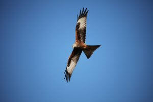 Red Kites are magnificent birds of prey were successfully reintroduced to the Chilterns in the early 1990’s. Human persecution had led to their extinction in England by the end of the 19th century; in fact red kites last bred in this area in around 1830. They are mainly scavengers, picking up carrion from the roads and surrounding countryside, but will catch small mammals, insects and worms. Sometimes teddy bears are found in their nests, presumably mistaken for dead animals!
Bottom Wood
Bottom Wood is owned by the Chiltern Society and managed as a nature reserve. The 36 acre site covers the valley bottom and steep south-facing slope. About 80% of the reserve is ancient woodland and the remainder is now chalk grassland. The wood supports over 700 different kinds of plants and animals, including dormice and several other rare British species. The bridleway that passes through it is an old packhorse trail taking the line of least gradient from Wycombe to Stokenchurch . There are some references suggesting it could also have been a coaching route.
Fillingdon Farm
Fillingdon Farm is the home to Art of Africa. All their work is original handcraft, made where possible from the natural materials for which Africa is famed; stone, silver, cotton, clay, wood, mohair, leather etc. They hold two major exhibitions every year and are open by appointment for the remainder of the year.
The Wycliffe Center
At the time of writing the centre has been demolished and awaiting the construction of a retirement village. The site was originally a camp for disabled evacuees during WWII and was later bought by Lancashire County Council for a boy’s boarding school. It later became the UK Headquarters of Wycliffe Bible Translators who has translated the bible into around 2,000 languages.